Randonnée Voiture Galway Municipal District - j04-1 - Photo
 DUPORT16
DUPORT16

Utilisateur

© OpenStreetMap contributors
Longueur
Longueur
36 km
Altitude max
Altitude max
40 m
Dénivelé positif
Dénivelé positif
219 m
Km-Effort
Km-Effort  
39 km
Altitude min
Altitude min
0 m
Dénivelé négatif
Dénivelé négatif
247 m
Boucle
Boucle
Non
Date de création :
2023-05-27 08:18:08.624
Dernière modification :
2023-05-27 09:02:31.001

(0 Avis)

Voiture
Voiture
44m
Difficulté : Très facile

Scannez ce code QR pour ouvrir la randonnée dans l'application SityTrail

Application GPS de randonnée GRATUITE

Logo SityTrail SityTrail

IGN / Instituts géographiques

Télécharger SityTrail sur l'App Store Télécharger SityTrail sur Google Play

Logo SityTrail SityTrail World

Le monde est à vous

Télécharger SityTrail sur l'App Store Télécharger SityTrail sur Google Play Télécharger SityTrail sur Huawei AppGallery

À propos

Randonnée Voiture de 36 km à découvrir à Inconnu, County Galway, Galway Municipal District. Cette randonnée est proposée par DUPORT16.

Profil altimétrique

Localisation

Pays :
Irlande
Région :
Inconnu
Département/Province :
County Galway
Commune :
Galway Municipal District
Localité :
Rahoon
Départ:(UTM)
494218 ; 5902384 (29U) N.

Randonnées à proximité

Randonnée Voiture Galway Municipal District - J-4_Irlande_27-05-2023 - Photo
Voiture
force

Voiture

Très facile
Galway Municipal District, Inconnu, County Galway, Irlande
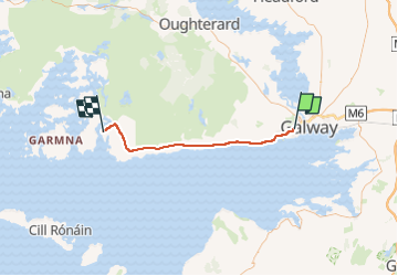
155 km | 166 km-effort
4h 16min
Non
Randonnée Voiture Galway Municipal District - j5-1 - Photo
Voiture
DUPORT16

Voiture

Très facile
Galway Municipal District, Inconnu, County Galway, Irlande
100 km | 113 km-effort
5h 7min
Non


Fermer
Mes abonnements